Unique Places around the World
Our earth is an incredible planet and with the
advent of technology, remote and hidden places have been finding their way into
the eyes of the world. It is not possible for everyone to keep travel
everywhere, nevertheless the internet gives a picture view into the places one
can’t physically visit, and opens up the wonders of our planet. This list below
looks at some of the most unique areas around the world and also includes
natural areas as well as those created by humans.
Spotted Lake of
Osoyoos (British Columbia Canada)
Osoyoos is known for its warm summers, gorgeous
lakes, unique desert wildlife and great outdoor activities. It’s home
to the Nk’Mip Desert, Canada’s only true desert environment,
and the unique natural formation of Spotted Lake – a huge draw for
visitors to the area. This mineral lake is located along Highway 3, northwest
of Osoyoos in the Eastern Similkameen Valley.
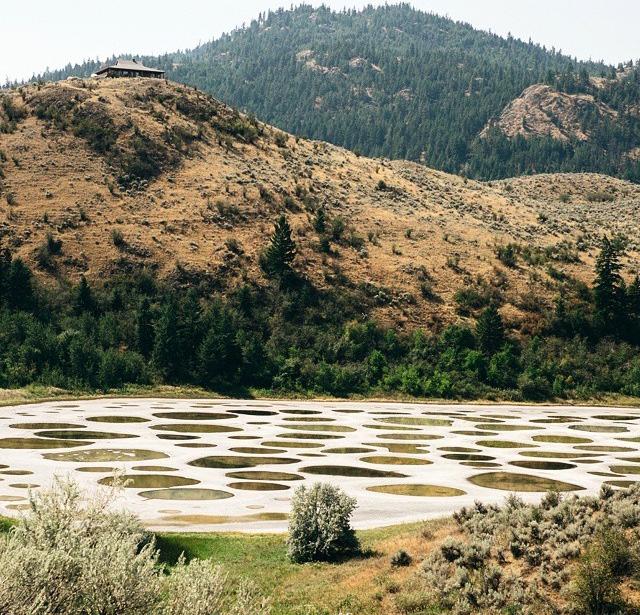
Spotted Lake is a small lake rich in a variety
of minerals, including calcium, sodium sulphates and magnesium sulphate. During
the hot summer months, much of the water in the lake evaporates, leaving
concentrations of these minerals that form the spots visible in the lake.
Throughout the summer, the spots shift in size and colour as the minerals
within each change with further evaporation. Colours ranging from blue to green
to yellow appear, depending on the mineral makeup of each individual spot.
The Plain of Jars (Lao)
The Plain of Jars is a group of fields containing thousands of
stone jars cut out from rock thousands of years ago. The sites are located
around the city of Phonsavan in Xiangkhouang province, North East Laos. While
some of the sites contain just a few jars, others contain hundreds many of
which are broken or have fallen over. The Plain of Jars have been submitted to
the Tentative List of UNESCO World Heritage Sites.

The history of the stone jars is shrouded in mystery. The jars
are believed to be about 2,000 years old. They come in varying sizes up to
three meters high, weighing up to several tons. Most of them were sculpted from
sandstone rock. Very little is known
about the people who created the jars. Although their purpose is not known with
certainty, archeologists believe they were used as urns in burial rituals. All
jars are now empty. During archeological research in the 1930’s glass beads as
well as burnt bones and teeth were found inside. Around the jars archeologists
found grave goods and bones. The jars were probably originally sealed off with
lids. Today only a single jar contains one. A few stone lids have been found
between the jars, others might have been made of wood or other perishable
material that has long gone. Stone discs between the jars mark the location of
a grave.
Nine Hells of Beppu (Japan)
Beppu is home to over 2,800 hot springs and is found on the island of
Kyushu. The Nine hells of Beppu are some of the more unique springs in the
area. Hell 1 is Umi Jigoku meaning “sea hell”. The pool is a turquoise blue and
is hot enough to boil eggs. Hell 2 is Oniishibou, meaning “shaven head hell”
and gets its name from the boiling gray mud. The mud bubbles to the surface and
resembles the shaved head of Buddhist monks. Hell 3 is Shiraike Jigoku meaning
“white pond hell” and is filled with boiling white water caused by the high
calcium concentrations.

Hell 4 is Yama Jigoku meaning “mountain hell.
Yama Jigoku was made by a mud volcano that spewed so much that it created a
small mountain surrounded by small pools. Hell 5 is Kamada Jigoku “cooking pot
hell”. This is a collection of boiling hot springs that are flanked by a red
devil statue featured as the cook. Hell 6 is Oniyama Jigoku, meaning “devil’s
mountain hell”. Oniyama is a very strong stream that can pull 1 ½ train cars,
and is also home to about 100 hellish crocodiles. Hell 7 is Kinryu Jigoku
“golden dragon hell”. This spring is featured with a steaming dragon. The steam
is supplied by the steam of the spring and is directed out of the dragon’s
nostrils. The dragon gives the illusion of flying when water spouts out at
sunrise. Hell 8 is Chinoike Jigoku, meaning “blood pond hell”. Chinoike gets
its name from the bright reddish colored water caused by ferrous (containing
iron) minerals in the pond. Hell 9 is Tatsumaki Jigoku, meaning “spout hell”.
Tatsumaki is a geyser that spouts every 30 minutes and has a temperature of
about 105 degrees Celsius.
Pamukkale (Turkey)
The surreal, brilliant white travertine
terraces and warm, limpid pools of Pamukkale hang, like the petrified cascade
of a mighty waterfall, from the rim of a steep valley side in Turkey’s picturesque
southwest. Truly spectacular in its own right, the geological phenomenon that
is Pamukkale, literally "Cotton Castle" in Turkish, is also the site
of the remarkably well-preserved ruins of the Greek-Roman city of Hierapolis.
With such a unique combination of natural and man-made wonders it’s little
wonder that Pamukkale-Hierapolis has been made a Unesco World Heritage site.
With over two million visitors annually, it is also Turkey’s single most
visited attraction.

The best way to approach the ancient site is to walk up through the
formations on the travertine path, starting at the south gate to the site. You
are not permitted to wear shoes or even sandals to do this (to prevent eroding
or staining the delicate calcite deposits) so bring your footwear (and
everything else you’ll need for exploring the ancient ruins) along in a bag.
Wearing swimwear allows you to splash in the warm, aquamarine pools en-route,
and later swim in the antique pool at the top of the terracing. Allow the whole
day to make the most of the travertines, pools and remains - bring a picnic
lunch (and plenty of water/suncream etc in mid-summer).
Chamarel Falls and the Colored Earth (Mauritius)
The
seven colored earth is a natural phenomenon and a prominent tourist attraction.
The colors evolved through conversion of basaltic lava to clay minerals. It is
a relatively small area of sand dunes comprising sand of seven distinct colours
(approximately red, brown, violet, green, blue, purple and yellow).

Due
to the tropical weather conditions, all water-soluble elements such as silicon
dioxide have been washed out. The remains are the reddish-black iron- and aluminum oxides which create shades in blue, cyan and purple. The
various colors developed due to the different compositions. Sunrise is the best
time to see the Coloured Earths. Geologists are still intrigued by the rolling
dunes of multi-coloured lunar-like landscape. The colours, red, brown, violet,
green, blue, purple and yellow never erode in spite of torrential downpours and
adverse climatic conditions. The Colored Earth of Chamarel has become one of
Mauritius' main tourist attractions since the 1960s. Nowadays, the dunes are
protected by a wooden fence and visitors are not allowed to climb on them,
although they can look at the scenery from observation outposts placed along
the fence. Curio shops in the area sell small test-tubes filled up with the
coloured earths.
Sanqingshan (China)
Mount
Sanqing is a renowned Taoist sacred mountain located 40
kilometres north of Yushan County in Jiangxi Province, China
with outstanding scenery. Sanqing means the "Three Pure
Ones" in Chinese as Mount Sanqing is made up of three main summits: Yujing,
Yushui, and Yuhua, representing the Taoist trinity. A Chinese phrase
explains why it was named San Qing. Amongst the three hills, the Yujing
hill is the highest.

Mount
Sanqing has been classified as a national park of China. It is a
famous honeypot as well as a shelter for animals and plants. It
contains more than 2300 species of plants and 400 species
of vertebrates. The total area of Mount Sanqing is 229 km². It became
a National Geopark in 2005 and a UNESCO World Heritage Site in
2008
Caño Cristales (Colombia)
Caño
Cristales is located in a remote, isolated area not easily accessible by road.
Adventurous tourists can now fly into the nearby town of La Macarena. From
there it is a short trip into “Serrania de la Macarena,” the national park in
which Caño Cristales is located. The site was effectively closed to tourists
for several years because of guerrilla activity in the region along with
concerns about the impact of unregulated tourist traffic. It was reopened to
visitors in 2009, and today there are several Colombian Tourist Agencies that
will fly travelers to La Macarena. From there, they must make their way to the
river site on horseback (or donkeyback) and by foot as part of a guided tour.
Visitors are not permitted to stay overnight or cook.

Most of
the year, Caño Cristales is indistinguishable from any other river: a bed of
rocks covered in dull green mosses are visible below a cool, clear current.
However, for a brief period of time every year, the river blossoms in a vibrant
explosion of colors. During the short span between the wet and dry seasons,
when the water level is just right, a unique species of plant that lines the
river floor called Macarenia clavigera turns a brilliant red. It is offset by
splotches of yellow and green sand, blue water, and a thousand shades in
between. This only happens for a brief period in between seasons. During Colombia’s wet
season, the water flows too fast and deep, obscuring the bottom of the river
and denying the Macarenia clavigera the sun that it needs to turn red. During
the dry season there is not enough water to support the dazzling array of life
in the river. But for a few weeks from September through November, the river
transforms into a veritable living rainbow.
Vale Da Lua (Brazil)
On private property
close to Chapada dos Veadeiros National Park is an amazing and ancient place
much like a water park created by nature with pools, natural water slides and
cascades. It’s called Vale da Lua or Valley of the Moon due to the
smooth rocks formed by river and ancient lava flows. Still others call it Moon
Valley. The rocks are very unusual and some consider them to look like lunar
rocks. This Moon Valley is not well-known, not even among the people of Brazil.

Rio Tinto (Spain)
Considered
the birthplace of the Copper Age and Bronze Age, the river Rio Tinto is tinted
red from 5,000 years of mining. The Red River is often considered the
birthplace of both the Copper Age and Bronze Age. The Iberians and Tartessians
in the area began mining the river in 3000 BCE, followed by the Phoenicians,
Greeks, Romans, Visigoths, and Moors. For hundreds of years, the river’s mines
were abandoned until rediscovered and operated by the Spanish government in
1724.

After
large-scale excavations by companies from the United Kingdom in the 19th
century made the river extremely dangerous for people because of the high
acidity level, the multinational Rio Tinto Company was formed to operate the
mines. Rio Tinto no longer manages the river, but by the end of the 20th
century it had become one of the world’s largest mining companies. The high
acidity keeps people away from the waters, but draws scientists in. Extremophile
aerobic bacteria in the water provide conditions similar to those found in
other areas in the solar system. Jupiter’s moon Europa, for example, is thought
to contain an acidic ocean underneath its surface. Life in the Rio Tinto - the
bacteria feed on iron and sulfide minerals in the river’s subsurface rocks -
make the likelihood of life on Europa all the more possible.
Fly Geyser Reno (Nevada)
Nestled on a patch of private land in Nevada’s
Black Rock Desert, the Fly Ranch Geyser (known commonly as the Fly Geyser) is
one of the state’s coolest attractions, though many residents still do not know
it exists. Fly Geyser, which spews waters about five feet high, lies about a
third of a mile from State Route 34, a road which functions as the only
viewpoint since the geyser is not open to the public.


No comments:
Post a Comment